Google Earth
Both the Avia S-199 book and the central Asian research I'm doing for Reader's Digest (Canada) involve niggling little villages, sometimes defined by a mere building.
The search engine built into Google Earth can be helpful, but on so small a scale it often fails to find what I need. The software makes up for this deficiency by allowing third-party developers to produce plug-ins, in the form of .kmz files.
Now, you'd suspect any Web site called Palestine Remembered, al Nakba 1948 (al Nakba translates to "The Catastrophe") to have a measure of ideological rigidity - and you'd be right. Depite the name, despite the mission, the site presents some good work. One of the spectacular resources it offers is a .kmz file of villages in 1948 Israel/Palestine.
Cruise Google Earth's fora and you'll find plenty of political discussion over this map, but that fails to detract from this plug-ins value. It's an amazing resource, and not only for the expected mapping of former Arab villages. The file also maps Jewish settlements and those villages that were bi-cultural. You may read about Faluja (not the one in Iraq) and Beit Jibrin, but where were they? And why were they so important?
This map shows you. There's some discrepancy in English spellings of Arabic and Hebrew placenames, but that's a minor inconvenience.
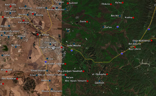
I'd be lost without it.
Bonus political commentary:
It's voting day here in Quebec. I've carried out my civic duty and now all I can do is wait. Will my riding, which has elected a Liberal MNA every election since approximately the Big Bang (with a brief interruption from the late lamented anglophone-rights Equality Party), do so again? I'm on tenterhooks.
The search engine built into Google Earth can be helpful, but on so small a scale it often fails to find what I need. The software makes up for this deficiency by allowing third-party developers to produce plug-ins, in the form of .kmz files.
Now, you'd suspect any Web site called Palestine Remembered, al Nakba 1948 (al Nakba translates to "The Catastrophe") to have a measure of ideological rigidity - and you'd be right. Depite the name, despite the mission, the site presents some good work. One of the spectacular resources it offers is a .kmz file of villages in 1948 Israel/Palestine.
Cruise Google Earth's fora and you'll find plenty of political discussion over this map, but that fails to detract from this plug-ins value. It's an amazing resource, and not only for the expected mapping of former Arab villages. The file also maps Jewish settlements and those villages that were bi-cultural. You may read about Faluja (not the one in Iraq) and Beit Jibrin, but where were they? And why were they so important?
This map shows you. There's some discrepancy in English spellings of Arabic and Hebrew placenames, but that's a minor inconvenience.
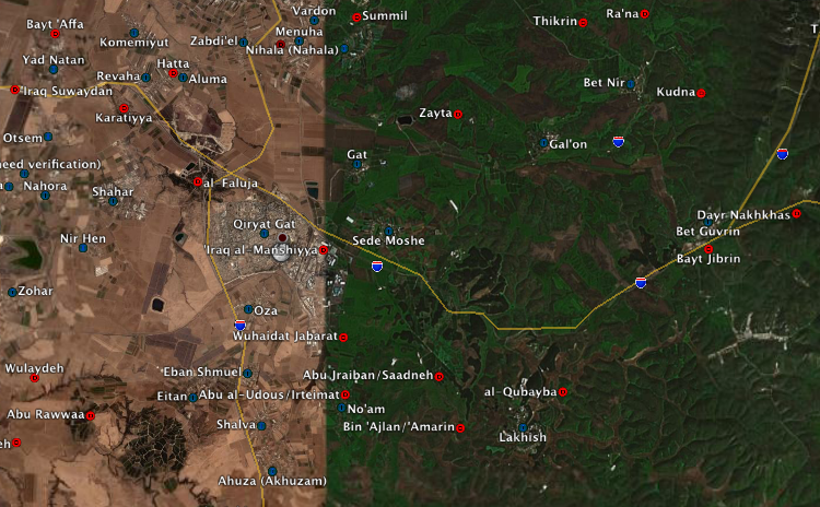
I'd be lost without it.
Bonus political commentary:
It's voting day here in Quebec. I've carried out my civic duty and now all I can do is wait. Will my riding, which has elected a Liberal MNA every election since approximately the Big Bang (with a brief interruption from the late lamented anglophone-rights Equality Party), do so again? I'm on tenterhooks.
posted by Webs at
1:21 PM
![]()


0 Comments:
Post a Comment
<< Home